Eagle Cap Wilderness - July 2025
TL;DR - it was fun; just show me the pictures.
Fourth of July means we’re looking to get away from civilization. Living adjacent to the Nooksack Indian Reservation means a lot of fireworks, and Baker would not want any of that.
We decided to return to the Eagle Cap Wilderness in the Blue Mountains of northeast Oregon, eight years since the holiday weekend trip we did in 2017. We didn’t go very far up-valley that trip, so we had some unfinished business.
The downside is that it’s a solid 8+ hour drive from Deming, so we again broke the drive out in two phases. We left Wednesday after work and stopped at Sand Hollow campground, which is almost right in the middle of the state along the Columbia. We stayed there in March when we stopped on our way to the Badger Mountain Challenge, with the camper, and discovered it’s a very clean and well-run campground, and you can generally count on first-come sites any time of the year. Its only real amenity is that it’s on the Columbia River. We just had the 4Runner this time, and the trip across I-90 was noticeably windy. When we got to the campground, the winds were really blowing, with serious whitecaps on the Columbia and waves crashing on the camp’s shoreline.


There were maybe six or so groups at the campground, and one group of middle-aged folks had tents pitched up that were taking quite a beating. The combination of wind, dust and sand really tested them, and they were visibly struggling with getting dinner going out the back of their trucks. The campground has tent loop/anchors built into the concrete campsite ground dividers…it’s very obvious why. We converted the 4Runner into its sleeping configuration, with Baker in the driver’s seat and our gear secured in the other seat. Still, though, the dust and wind was strong and we were happy to be solidly bedded down in the back of the SUV and not dealing with wind drama. When we packed up early the next morning, the sleep-deprived tent folks were just getting up; one of their tents was busted up, poles all akimbo.
We still had over five hours of driving ahead of us, then another 3 hours of backpacking. We enjoyed Washington’s varying landscape except that exceedingly boring stretch of SR 26 as we drove southeast, stopping at Safeway in Walla Walla before taking the very rural route towards Lostine, the namesake of the Lostine River that we’ll be hiking alongside. The road to the trailhead was moderately washboardy, passing many campgrounds, and we arrived at the trailhead a little after 1PM I guess.
The trailhead is very built-out as trailheads go. The parking spots had rubber dividers between each vehicle slot, I guess to ensure uniform parking. We gathered our gear and had a quick picnic lunch before heading up the East Fork Lostine River trail.


The trail is pretty chill, climbing gently from the trailhead elevation of 5,600ft toward the upper valley over 7,000ft. You’re never far from the river, and the trail meanders in and out of shade. The creek and trails fork very early on; we stayed left up the east fork. Soon we crossed the East Lostine on a log bridge, and after a bit came to a great spot to rest, grab a snack and enjoy the view of a powerful waterfall right off the trail.


Soon the trail hits the only steep part of the trail, about a third of a mile of steep switchbacks where you gain most of the elevation to the upper valley. In our first trip in 2017, about the time we exited the switchbacks we had pretty significant snowfields to navigate in and around the trees. We recalled that it was rather annoying back then, but this time, the snowfields were fewer and we made good time through the forested valley before we broke out into the bigger views on the upper part of the five mile-long valley, no doubt once buried beneath thousands of feet of glacier ice eons ago.


Only a small portion of the trail was snow-covered, and we were ever-vigilant for hidden snow bridges; thankfully they weren’t much of an issue, though Baker did get caught on a few when he went too close to a melted edge.

We crossed the river again on a few shaky logs that replaced the seemingly stout bridge we sauntered across eight years ago. A couple had stopped to rest there, and they were swarmed by mosquitos. We hustled on; we were sort of on the fence about pushing another couple of miles up to Mirror Lake after our long day, but decided to look for a spot in the secluded upper valley, away from most other campers.

That’s not a rock, that’s our tent.
We found a spot in a copse of trees with an area big enough for our tent. We generally prefer sites like that due to privacy and protection from wind and rain. Most other campers we passed down-valley were plopped in the middle of the valley, generally on one of the many campsites, just like we were on our last trip when we were probably the only campers in the valley. I guess there were three to four other groups staying in the valley that night, many had pushed up to Mirror Lake earlier in the day.
The upper valley is so serene with all the meandering snowmelt creeks converging. Several waterfalls along the valley walls above us were cascading down, adding to the constant white noise. The mosquitos were moderately annoying as we ate dinner, but not as bad as I expected, thankfully. I had my permethrin-treated hoodie and pants on, and they never seemed to bother. Beck got a few bites, but only need to use her head net a few times.
As it got later, I noticed the golden light on Eagle Cap, and we spent the next 30 minutes in the orange and red glow, snapping pictures of both ends of the valley as the sun set down.


As we settled down in our tent after the fireworks show, I pulled the forecast from the Garmin and saw that rain was forecast overnight into the Fourth. We’ve never gotten a bad forecast from the Garmin, so we ensured all our items were properly stored for rain.
Very light rain started and was off and on most of the night; the trees around us acted like umbrellas, but eventually they soak through and their bigger drops make louder sounds on the rain fly. We were comfortable and stayed in the tent most of the day; somehow I was able to actually sleep/snooze through most of it. Maybe the long drive the previous day sapped me a bit more. Or maybe I’m just old. Probably both.
The rain stopped later in the afternoon, so we gathered up some snacks and headed up to Mirror Lake, just over a mile up the trail. Our original plan was to push up to Mirror Lake earlier that day, but with the rain and all, I decided to at least delay doing that until later or the next day. In retrospect, we should have just packed everything up and gone up there.


There was a lot more snow to contend with, and following the trail was harder, but we climbed another few hundred feet and reached the upper lake basin, which is actually called ‘Lake Basin’ on the USGS map. It is a gorgeous area with the mostly snow-covered peaks building up toward Eagle Cap reflecting off the granite-walled lakes. At around 7,500ft, it’s no surprise that it looks very much like The Enchantments with same sort of ground cover, big granite slabs, and classic alpine lakes around every glacier-carved corner.

Every so many hundred yards or so we’d encounter campers in big obvious sites or tucked higher up and off the trail. There were so many campsites, but many of them conflicted with the very clear rules on the permit and signs at the trailhead stating not to camp within a hundred feet of the lakes. I honestly am glad to see this place so early in the season, as I’d imagine come prime backpacking season, this place would be overrun.
The other big surprise was the complete lack of backcountry toilets; at least we never found any or any signage for them. This granite landscape doesn’t offer nearly as many opportunities to dig catholes, and they don’t encourage you to pack it out, which, in many areas, is now the norm, so…..yeah, there’s a problem. Plus, this spectacular area is less than nine miles from two different trailheads, so it must be a literal shitshow at times. What stood out to me was how built-out and informed everything was at the trailheads, with the signs, the nice picnic area, pit toilet, etc., yet no toilet boxes or pit toilets up here, where they’re really needed.
We explored up there for probably 30-45 minutes as the sun was setting; I ran around trying to get decent shots of the reflections, as the wind had calmed and Mirror Lake was doing its thing. After the light show, we headed back down to camp, spending more time on the upper of the two trails that make its way between the valley and the upper Lake Basin.


Next morning Beck read a book in the meadow while I wandered around with Baker; sticks were the primary focus for him. The water is so clear as it runs over light-colored granite gravel. Beck decided that we should try to climb up toward a waterfall we enjoyed from camp, so we puzzled our way across the creeks that were just a little too wide to hop over. We made it up there and had another snack along the falls. We looped back a different way and I decided to just walk through the creek instead of messing with finding a drier route. Good chance to clean off our shoes..


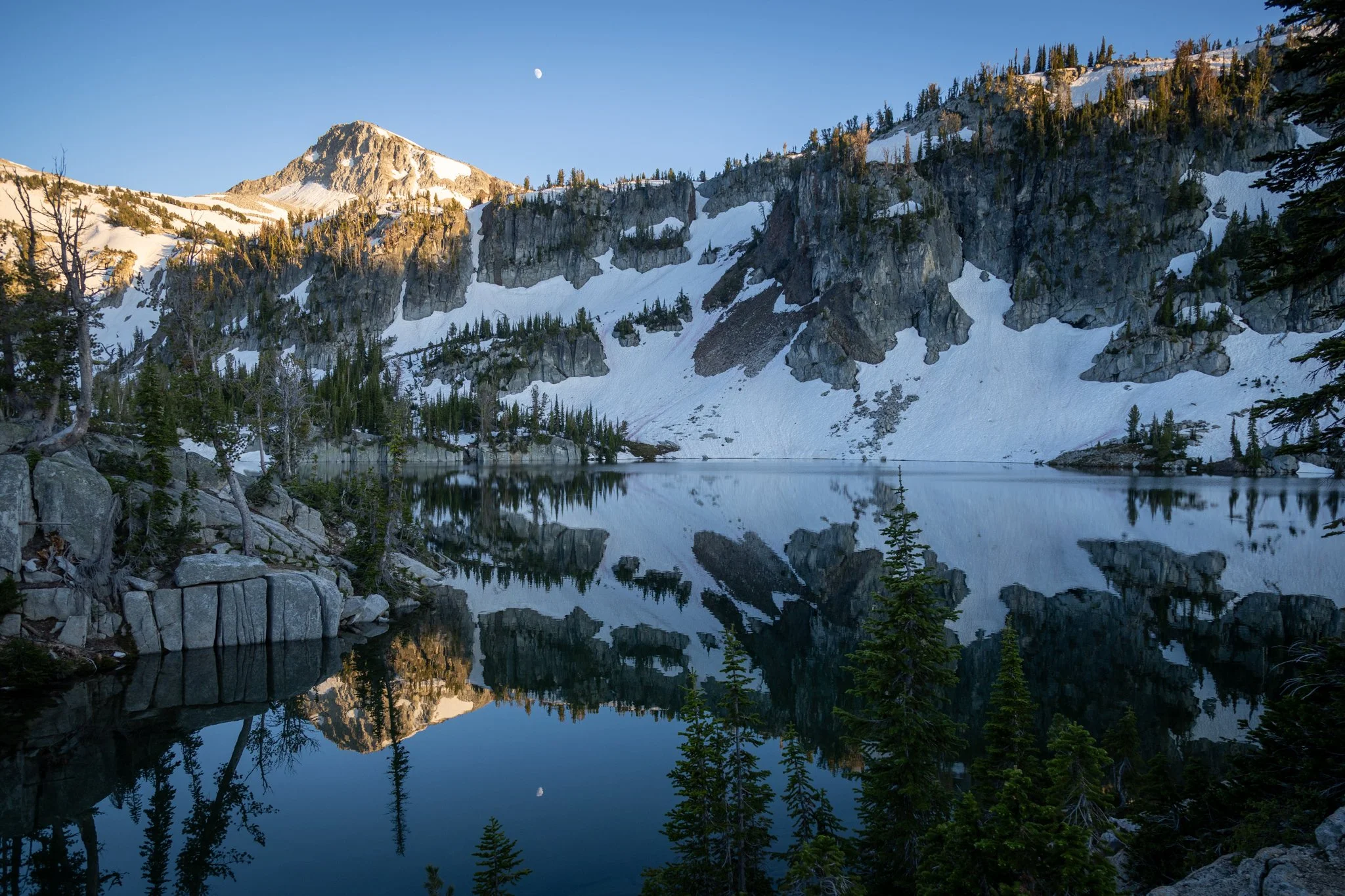
We lazed around in camp, set up our hammocks and snoozed, and eventually had dinner before hiking back up to Mirror again for another sunset. This time, the moon was showing itself and set up for some nice pictures.


Beck had been eyeing to hike up Eagle Cap, as it’s generally a walk-up, non-technical hike gaining another 2,000ft from the lakes. However, the snow looked pretty formidable without any protective crampons or ice axe. Beck was curious and egging an attempt, but I wasn’t interested as it looked a bit too risky. At the end of our trip a day later, we ran into some guys at the trailhead who had indeed gone up Eagle Cap without any gear and said it wasn’t that bad. Beck was naturally disappointed to hear that. :-/
After another good night in the tent, we packed up our stuff and headed down. Beck had an exciting moment as she crossed the logged bridge. She almost fell in right away twice, teetering on the logs with her poles, and after catching herself twice, she lost her balance falling forward, but instead of falling into the creek very awkwardly, she just lunged forward and her foot caught a grassy knob on the shore and she miraculously came away unscathed; it could have been very bad otherwise, as it was not a good place to fall.


The hike out was pretty quick and uneventful; just over seven miles of beautiful valley and forest, before popping out at the trailhead in late morning. Only eight hours of driving left to do….
